| |
| A
newcomer to Boquete from the northern latitudes such as North
America or Northern Europe quickly discovers dramatic differences
in weather, seasons and climate compared to their countries of
origin. These changes include the rather constant length of days
and nights,
the warm
and even temperatures, the dry and wet months and at times the
strong northern winds. A curious observer asks questions about
the causes
of these differences. |
| |
| The purpose of this article is to address these
questions and help understand the major factors influencing Boquete
weather and climate. This is a non-technical discussion with web
links to more detailed information. The organization is as follows: |
|
|
|
| |
| While
the scope of this discussion is limited to the major factors
that effect the weather and climate of Boquete
(Inter-Tropical Convergence Zone, Thunderstorms and Orographic
Lifting) it should be remembered that
weather (the day-by-day realities of our atmosphere), the seasons and climate
(the overall trends and patterns of weather over the course of the years)
are always the result of a complex dynamic interaction of factors that
include: the relative position of the sun, air temperature, air humidity,
clouds, precipitation, air pressure, and winds. These are the basic elements
of weather and climate. The weather of Boquete is no exception. |
| |
|
|
| |
Panama
is a relatively small strip of land in the shape of an “S” lying
on its back 1100 miles south of Miami, Florida. It is sandwiched
in between two large bodies of water, the Caribbean Sea to
the north, the Pacific Ocean
to the south. It is also bordered by two countries with Costa
Rica to the west and Columbia to the east (see Figure 1). To
get some perspective of its relative size, it is a total of
29,157 square miles which
is a bit
smaller than the state of South Carolina with 30,109 square
miles (See Figure 2). It is about 400
miles long running west to east and generally 50-70 miles wide
from north to south. (See Figure 3). It
has several
mountain ranges dissecting it in various
places. The western most mountain range continuing from Costa
Rica is the Talamanca Range in the State of Chiriqui. This
range includes
the countries tallest mountain, Volcan
Baru which is 11400 feet high (3475 meters) and home to tropical
rainforests. Panama is located
between 7 to 9 degrees
north latitude |
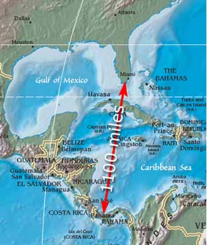 Figure 1. 1100 miles south of Florida
 |
from
the equator and between 77 to 83 degrees west
longitude placing it solidly in the tropics.
Panama is very
small in comparison to the large land masses of continental
North America and Europe.
Its weather is more affected by the large water masses around
it rather than by large land masses. In short, Panama is
a little piece of land with
highly varying terrain bathing in a large tub of water and
basking in a whole lot of sun!
Boquete
is not just a city although the town of Bajo Boquete is often called "Boquete." It
is a District with 6 Subdistricts (Corregimientos)
located in Chiriqui, the western most State (Province) of Panama
bordering Costa Rica (See Figure 3). It covers an area of 189
square miles (484 square kilometers) and has
a lot of topographical variation in terrain and elevation. The
altitudes range from 1200 feet in the
lowland areas
to 11400 feet (Volcan Baru the |
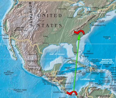 Figure
2. Smaller than South Carolina
Figure
2. Smaller than South Carolina |
| highest
point in Panama) in the highlands. Its southern boundary is the
lowest
part of the district which gradually slopes upward and northward
to
the Talamanca Mountain Range that runs east to west coming out
of
Costa Rica.
The city of Bajo Boquete (Lower Boquete) in the Subdistrict of
Bajo Boquete sits in a bowl like valley surrounded by Volcan
Baru to the west, the Talamanca Range to the north, the Jaramillo
Mountains to the east and an opening to the south after a slight
climb out of the valley to the
more open area of Alto Boquete which then slopes downward through
a barren savanna to the southern boundary of the District of
Boquete. The word Boquete in Spanish means a "hole" or
an "opening." Originally this area was called "El
Boquete" meaning the hole or opening to the valley. |
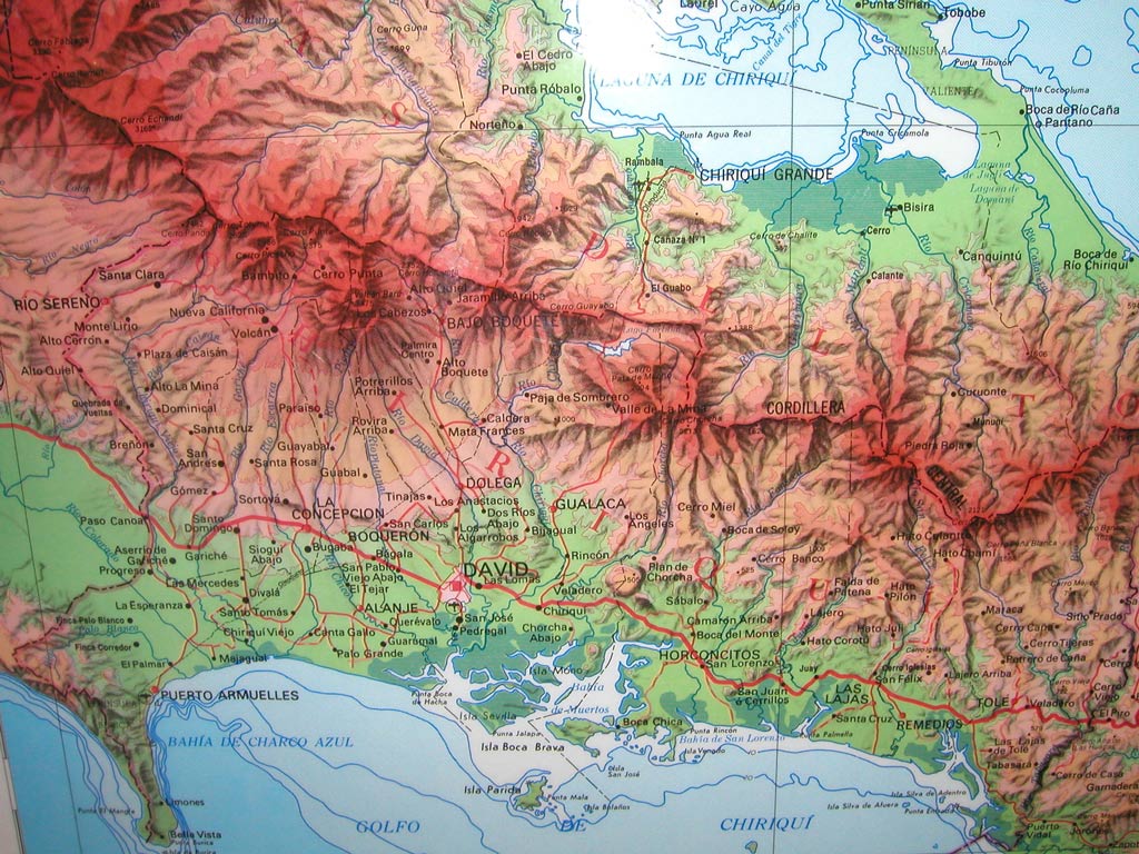
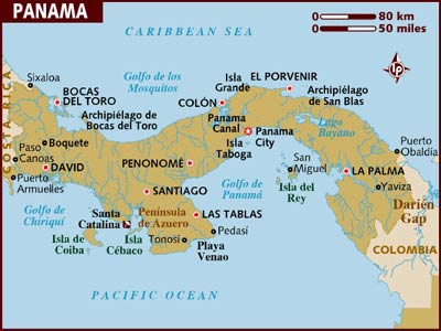 Figure
3. Lonely Planet Map of Panama
Figure
3. Lonely Planet Map of Panama |
About 12
miles south of the Boquete District boundary (in the Subdistrict
of Alto
Boquete)
and
25 miles
south of
the town of Boquete Bajo is the city of David (population
2005 138,241) the
capital
of
the State
of Chiriqui. The elevation of David is about 200 feet.
Driving
from David to Bajo Boquete is a gradual climb from 200
feet to 3500 feet. There is often a 20° F decrease in outside
temperature from David to Bajo Boquete. The
District of Boquete has a lot of varying terrain with
valleys, plateaus,
hills,
mountains,
ravines,
canyons and rivers. All of this variation provides conditions
for differing weather and many microclimates. Follow this link
to a large topographic map
of the Chiriqui area and this link
for an illustration of the District
of Boquete, a map of the 6 Subdistricts and
some data.
|
| |
|
|
| |
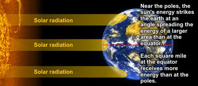
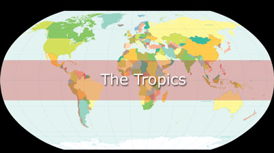
| The Tropics is
a designated area around the earth between 23.5° north latitude
(Tropic of Cancer) and 23.5 south latitude (Tropic of Capricorn).
This is the area of the earth that gets the most direct sunlight
during the earths yearly revolution around the sun (See Figure
4). Anyone living in this area receives more direct sun rays
and the sun passes more directly overhead during the yearly cycle.
In the Boquete area, the sun is most directly overhead in early
April and mid August of each year. |
 Figure
4. Tropics more direct Solar Radiation
Figure
4. Tropics more direct Solar Radiation |
 |
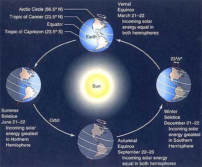
| During
the day, the sun heats the earth most
where the suns
rays strike the earth most directly. If the earth
had no tilt, there would be a band around the center of the earth
(between
10° N and 10° S latitudes) that would get the most direct
sun and consistently be the warmest part of the earth. However,
because the earth is tilted about 23.5° on its axis, as the
earth revolves around the sun each year, the part of the earth
that gets the most direct sunlight varies. This in large part is
what causes the seasons in the northern latitudes. |
For
example, in the northern winter months, the tilt causes the
suns rays to hit the earth less directly and at more of an
angle resulting
in less heating of the earth and cooler overall temperatures.
In the northern summer, the sun casts its light more directly
in the north and makes for warmer temperatures.
In relationship
to the earth, the path of the suns most direct radiation varies
from about 23 degrees north (Tropic of Cancer) to about 23 degrees
south (Tropic of Capricorn). If you live at latitudes greater
than 23 degrees north or 23 degrees south, the sun is never as
directly over your head. Yes, even in Florida or California,
the sun is
never directly overhead! However, if you live between 23 degrees
north or south latitudes, the sun will be more directly over
your head once or twice a year on the same dates depending
on your
latitude. |
 Figure
5. Tilt of Earth and Seasons
Figure
5. Tilt of Earth and Seasons |
| |
| At
8° north latitude, Panama is close to the equator. It is
between the Tropic of Cancer and the Tropic of Capricorn and
gets a lot
of sun. In April, the sun passes over Panama as
it moves on farther north and then passes Panama overhead
again in August on its apparent journey south.
This more direct solar radiation is the main reason that Panama's
temperatures and the tropics in general are warm with less temperature
variation than the far northern countries. |
| |
| The
tilt of the earth also affects the length of the day. If the
earth had no tilt, everyone on earth would have
12 hour days and 12 hour nights. Because of the tilt, days and
nights vary depending on your latitude. Near the equator the days
and nights are less variable in length (about 12 hours). In the
northern and southern latitudes, the length of days and nights
depend on the particular latitude where you are located and the
particular season. You probably remember those
long summer days
and those
short
winter
days while living up north? Panama’s length of days and
nights vary slightly over the course of the year but only by a
few minutes.
Boquete basically has about 12 hours of sunlight and 12 hours
of darkness throughout the year. |
| |
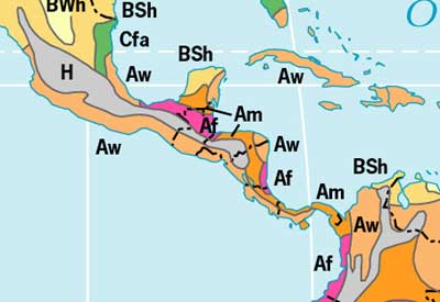
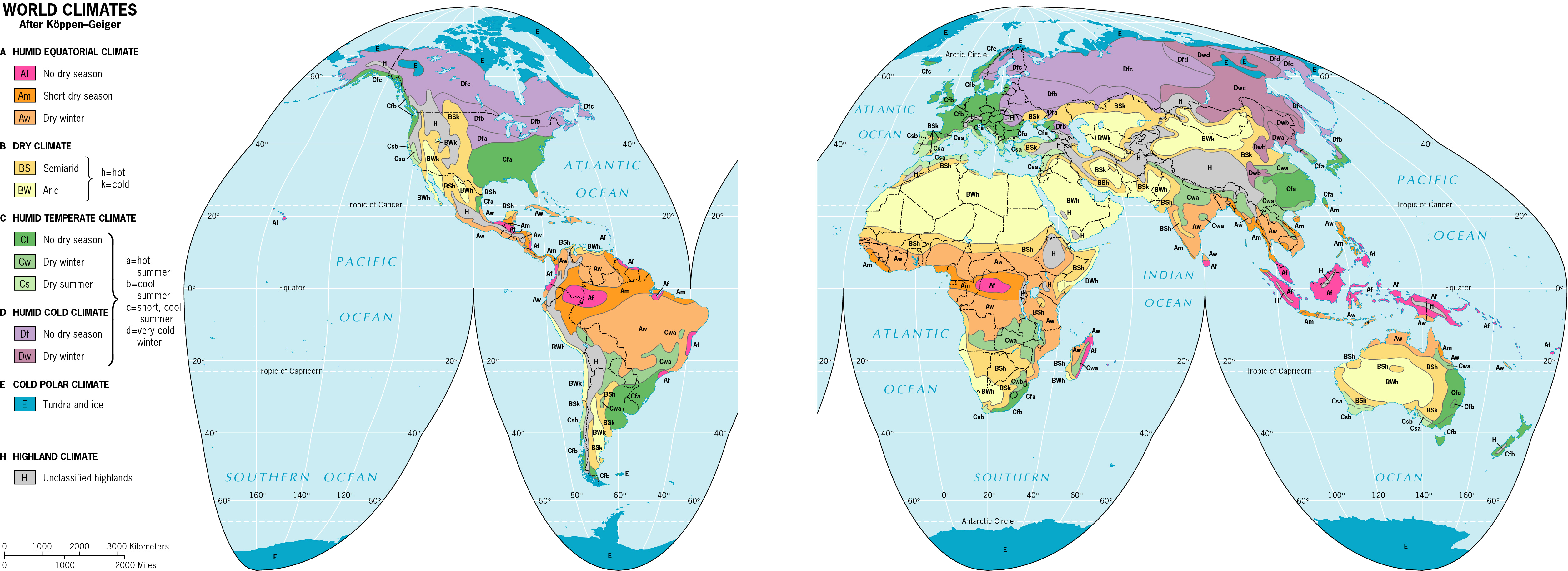
| World
climate patterns are typically classified with the Köppen
Climate Classification Scheme using average annual
temperature and precipitation data. According to this system
of
classification, Panama is a mix of “Short Dry Season” (Am)
and “Topical Wet and Dry” (AW) climates. "Am" climates
have a short dry season but sufficient moisture to keep the ground
wet throughout the year. "AW" climates have a distinct
dry season and at least one month with precipitation < 60 mm.
Here is a link to a good quality high resolution Köppen climate
map (1.9MB) with enough detail to show that
Panama is a mix of "Am" and "AW" climates.
Figure 6 is a clip of this map. Note that the northern
most
part
of the Boquete District and the Province of Bocas del Toro are
in the "Am" classification. The remainder of
the Boquete District is in the "AW" classification. |
Figure
6. Köppen Classification of Central America |
| |
| In
short, when you live in Panama, you are living on a little
piece of land with a lot of ups and downs bathing in a large
tub of water and basking in a whole lot of sun in
the
middle
of
the tropics! This helps to explain
why we have much warmer
temperatures than northern countries, but it doesn't completely
explain why we have a dry and a wet season? This comes next. |
| |
Inter-Tropical
Convergence Zone [top]
|
| |
| Before
diving into the main cause of our dry and wet seasons we need
to review a bit of basic meteorology. I will try and make this
as painless as possible. Perhaps you should go and get another
cup of that wonderful Boquete coffee before taking the plunge
into this section. Caffeine helps! |
| |
| Because
of the direct solar radiation on the earth, the land or water
beneath it is heated and this causes the air over it to be
heated and to rise. If the air is over large bodies of water
like oceans
or lakes, the water evaporates
into the air and the air becomes laden with moisture. Warm air
holds
a
lot
of moisture.
The heated
air rises. As this heated moist air rises, it eventually
cools, the water condenses around particles and clouds are formed.
If the clouds have a lot of moisture and and plenty of heat they
rise higher and higher until the water condenses
even further and it rains. The rising
of the heated air also causes upward air movement and a lowered
air pressure closer to the earth. Where there is a lower pressure
in the atmosphere, replacement air moves into the lower pressure
area to try and equalize the pressure. This causes air to flow
into
the
low pressure area which will then rise upward again with moist
air making a continuing circulating mass of air. |
| |
| Due
to the heat from the direct solar radiation that circles the
equatorial zone of the earth, a lot of warm moist air rises
in this area creating a low pressure at the surface. Air
flows
into
this
low
pressure
area from the
northern hemisphere (northeasterly winds) and from the southern
hemisphere (southeasterly winds). Where the winds come together
(converge) the warm air rises
upward very high (troposphere)
where it then bends and flows northward and southward
toward the respective
poles (see Figure 7). At about 30° north and south latitudes
the flow of air bends downward toward the surface to lower pressure
areas
below and then flows back toward the equator to once again converge
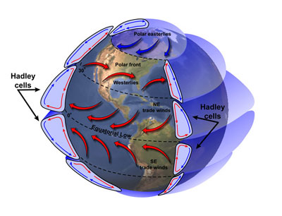
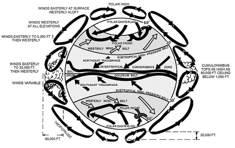
and rise. This flow of circulation forms air cells called Hadley
Cells which generate the earth’s major air
circulation masses and related wind systems (See Figure 8 from
Lutgens and Tarbuck, 2007). These air movement systems are also
affected by the rotation of
the earth
which bends and changes
their direction (coriolis
force). The
circulation cells that most affect this part of the world form
the Trade Winds. In
the northern hemisphere
the
Trade
Winds begin about
30° north
latitude and blow in a northeasterly direction toward the lower
equatorial pressure.
In the southern hemisphere the Trade Winds begin about 30° south
latitude and blow in a southeasterly direction toward the lower
equatorial
pressure. Where the winds meet near the equator,
the
air
is of course heated,
the pressure lowered, and if it is over water gets filled
with moisture to rise again and continue the ongoing cell dynamics. |
Figure
7. Basic Circulation in Equatorial Zone
 Figure
8. Hadley Cells and Winds
Figure
8. Hadley Cells and Winds
|
| |
| The
low pressure equatorial area were the flow of northeasterly and
southeasterly winds converge and the sun heats the land or water
causing moisture filled air to rise into towering cumulous clouds
(cumulonimbus) is one of nature’s most
powerful energy systems that fuels tropical weather. This
system encircling the earth is called he
Inter-Tropical
Convergence
Zone
(ITCZ). It is where the Trade Winds converge, pressure remains
low, and lots of towering clouds with thunderstorms develop.
It is an area of relative calm horizontal surface winds
known as the “Doldrums” named
by sailors of the past because of the hot humid nonmoving air that
could stall sailing vessels for long periods. The ITCZ is an area
where there are many clouds, thunderstorms, lightning and
heavy downpours of rain. Consequently, the ITCZ is
also
the water
system for the lush verdant belt of vegetation know as rainforests.
The ITCZ nurses the Earth’s
Tropical Rainforests. The ITCZ is not a continuous band
around
the earth
but rather
a discontinuous band due to a number of factors that include the
differing temperatures of land masses and ocean areas
(See Figure 9 from Lutgens and Tarbuck, 2007 and figure 10). |
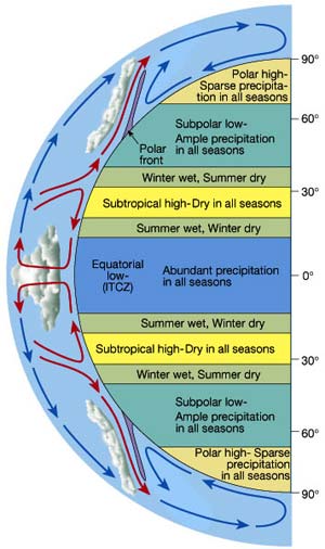 Figure
9. ITCZ and Hadley Cells
Figure
9. ITCZ and Hadley Cells |
| |
|
Figure
10. ITCZ, Hadley Cells and Wind Systems |
| |
| If
the ITCZ continuously encircled the earth
and did not move north or south, there would be a band of
clouds and thunderstorms stationed around the center of the earth
in the same area
that would generate a constant band of warmth and precipitation.
You can think of it this way, if you were standing somewhere
under
such
an ITCZ, you would be warm and get very wet! It would be hot
and humid all the time. If you were not standing under it, but
standing either to the north or south of this ITCZ you would
be warm but dry. |
| |
Due
to the tilt of the earth, the ITCZ is not static but migrates
north
and south
over the course of the year. During the months of January and
February, the ITCZ is in a southern most position while during
the months
of July and August, it is in a northernmost position (See Figure
10). In
Panama, the ITCZ moves south of us from December to April and
moves upon
us from May to November. As it leaves and moves more south
of us, we have little or no rain – the Dry Season.
When it moves more northerly and is closer to us or over
us, we have rain, usually in the form of thunderstorms – the
Wet Season. The
months of April and November
|
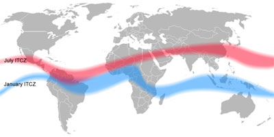 Figure
10. ITCZ shift from January to July
Figure
10. ITCZ shift from January to July |
| are
usually transition months gradually
working us into or out of the Wet Season or Dry Season respectively. |
| |
| Here
are a couple of useful links to better understand the
ITCZ (Wikipedia,
MSN
Encarta). The article by Dr. Brian Giles at the MSN Encarta
Link is the best succinct description of the ITCZ that I have
found. Below is a beautiful NASA satellite image of the ITCZ
with
Panama down there somewhere. You can click on the image to download
a higher resolution file of the image.
|
| |
|
| |
| So
there you have it. The ITCZ is the culprit. It is the main large
atmospheric system that drives our wet and dry seasons. It
creates most of our tropical weather and
climate. So when it is either too dry or too wet in Boquete, you
can utter the four word curse “Inter-Tropical Convergence
Zone” or
use a four letter word "ITCZ" if you can pronounce it (It-see?). |
| |
|
|
| |
| Another
significant factor affecting Boquete District weather is the
wind. At times there are winds from the north. At other
times there are winds from the south. While at other times,
there are no winds. Typically, strong northerly winds occur
during
the dry season. |
| |
| The
northern hemisphere Trade Winds come from the northeast as a
result of the Hadley Cell dynamics mentioned previously. This
is the fuel that propelled early explorers on their trade journeys
from Europe to the Caribbean from which the name trade wind was
derived. When they got closer to the equator in the ITCZ, they
ran the risk
of no
winds
or
the
so-called "Doldrums." |
| |
| During
the wet season, while Boquete is under the strong influence
of the ITCZ, we are essentially in the “Doldrums” and
generally have little to no northern wind. When the ITCZ moves
south, we are no longer as directly under the influence of the
ITCZ
and become more directly bombarded by the northeast
trade winds that are rushing toward the lower pressure of the
ITCZ. When the ITCZ is in the most southerly position during
the months
of January, February and March, we experience the strongest northeastern
winds. Boquete can be a very windy place during these months.
This is nothing new. In 1911, the naturalist Henry Pittier
explored Chiriqui as well as other parts of Panama and wrote
about the adventure in a 1912 National Geographic article.
He rode horseback from David to Boquete. His description of the
3 day 25 mile journey is very interesting.
He commented: |
| |
"Going
north in the direction of the Chriqui Peak, one is soon
struck by the peculiar range of low hills running, as it seems
between
the plains and the mountains and parallel to the sea-coast.
The road winds between these and , mostly following the
Dolega River, ascends gradually toward El Boquete. The general
incline
is so insensible that one travels nearly 25 miles before
reaching the foot of the volcano, at an altitude of about 3000
feet.
The ride is mainly across savannas or through what ecologists
call a parklike landscape.
During
the dry season the long stretches, bare of arboreous vegetation,
are constantly swept by the north trade wind, which attains
its major intensity between 9 o'clock a. m. and 3 o'clock
p.
m., and is often of such violence that even the horses
find it difficult to stand and to proceed on their way. Every
detail
of the surrounding landscape bears the impress of the wind.
In the most exposed places the surface of the soil is submitted
to an active aerial erosion, the minute particles of the
ground being whisked away the moment they become loose." page
631
|
| |
At
times there are breezes from the south, but they are typically
milder than the northern trade winds. The southern breezes
are related to sea breezes as well as southeast trade winds. Sea
breezes are the result of the land heating
more rapidly
than the ocean. During the day, this causes
the cooler air off the water to blow inland. This tends to
push clouds inland that have formed over the water and the
shoreline.
Southeastern winds and sea breezes off the Pacific Ocean
often move the towering cumulonimbus clouds from the coast
and lowlands
northward. Which of course, delivers the thunderstorms in the
afternoons.
|
| |
| Yes
folks, the bad news is that there are winds in Paradise
as well as
thunderstorms and
earthquakes! But the good news is that there are few to no hurricanes
that directly hit Panama because of the routes
that hurricanes usually take in the hurricane rich Atlantic-Caribbean
area. Although the paths of hurricanes north of Panama can come close and have an impact on our weather, only one, Hurricane Martha in 1969, has struck Panama during recorded weather history.
|
| |
|
|
| |
| Another
consideration in understanding Boquete weather is the effect
that the rising terrain from David to Boquete has upon clouds.
As air rises, it cools. The cool air cannot hold as much moisture
and
as the
clouds
laden
with
moisture continue to rise, the moisture condenses, thunderstorms
develop and at a certain point buckets of rain pour forth. As
clouds
are
pushed by the winds from lower to higher terrain, the clouds
are lifted, cool and tend to drop their rain. This lifting of
clouds over mountains is called in meteorology orographic
lifting.
What typically happens
is that clouds rising over mountains drop their rain as they
rise and then on the other side have no rain left to donate on
the other side and there is drought on the other side (called
the "leeward side"). |
| |
|
|
| |
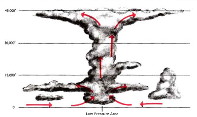
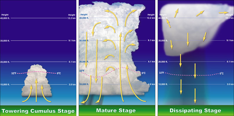
Thunderstorms are
the main vehicle delivering the rains to the Boquete District.
As the earth is heated during the day, air over heated water
gathers large amounts of moisture. As the air
rises,
clouds form and often evolve into the towering giant clouds called
cumulonimbus. These clouds develop rapidly and complete their 3
phase cycle within several hours or less (See Figure 11 below)
Note
that these
clouds
often
reach
to heights of over
40,000 feet. Lightning and
thunder are the awesome associates of these storms and harbingers
of quick heavy rains. Typically areas
of the world that are closest to the ITCZ have lots of thunderstorms
and lightning
strikes.
According
to Lutgens and Tarbuck (2007) over 2000
thunderstorms are in process at any given moment They
go on to say: "...As we would expect, the greatest proportion
occurs in the tropics, where warmth, plentiful moisture, and
instability are always present. About 45,000 thunderstorms
take place each day, and more than 16
million occur annually around the world.
The lightning from these storms strikes Earth 100 times each
second." Panama is an area
of the world that has numerous annual
thunderstorms
and
lightning
strikes.
These
are
awesome forces
of nature to be understood and respected. Living in Boquete,
it is worthwhile to become educated about thunderstorms and
be aware
of lightning
safety.
Develop a healthy respect for thunderstorms. |
| |
|
| |
Figure
11. Stages of Thunderstorm Development |
| |
| Now
that you know the basic facts that Panama is a small piece of
land, surrounded by water, in a warm place called the tropics,
with a
lurking culprit called the ITCZ (with associated thunderstorms,
a dry season, a wet season), times of strong northerly wind,
sea breezes, no wind, and that clouds pushed
inland over rising terrain
often dump rain, we can start talking more specifically about
the Boquete area and it’s
weather! This may be a time for some more of that Boquete coffee…. |
| |
The
Terrain of Boquete [top]
|
| |
| During
the Dry Season, the northeast trade winds come over the Caribbean
from the northeast but their exact entry into the Boquete District
is affected by the variations of mountain terrain elevation,
ridges,
and
ravines.
The friction from all of this variation alters
the course of
the winds. The surface winds from the Caribbean have to push
upward over, around and through
the
saddles
and ravines
of the
Talamanca Range and then drop down into the bowl or "the hole" of
Bajo Boquete and on down the slope to the lowlands of David to
the south.
Their course at the surface encounters many frictions. The
north
winds
vary
considerably in their strength and direction due to this geographical
adventure. Some places in the District are very windy while
others are not.
During
the dry season, especially the months of February and March, persistent
northern winds bombard the Boquete District with the variations
depending upon your particular location, niche or perch. Follow
this link for an illustration of the potential
effects of the terrain upon the
flow
of the
northeast trade winds through
the District of Boquete. |
| |
| During
the dry season, the northern winds can carry some moisture
over the mountain range from the Caribbean Sea into the northern
part
of the Boquete District. This is especially the case at the higher
elevations and into the Subdistricts of Los Naranjos,
Jaramillo and Bajo Boquete. Since the Boquete District
is on the leeward side of the mountains relative to the Caribbean
cloud
systems, the moisture that gets pushed over from the Caribbean
side usually comes in the form of a mist or light rain that is
locally called the “bajareque.” It
is a fine but very wet mist. Because of this dry season moisture,
the northern part
of the Boquete District
and the Province of Bocas del Toro get more constant rains and
are classified as Am tropical climates (short dry) rather than
Aw
(with wet
and
dry seasons) climates. |
| |
| During
the wet season, mornings are often clear with notable cumulonimbus
cloud systems forming in the south over the Pacific coast-line.
By afternoon
these clouds become
fully developed thunderstorm systems that often move inland (northward)
from David pushed by southerly
winds and sea breezes. These
towering systems make their climb
(orographic lifting) into the Boquete District. They dump
their heavy rains along the way from David and upward
toward the Talamanca Range. A more typical day during the
wet season in the Boquete District
is
to wake up
to generally clear skies and sunshine. As the day progresses, you
see cumulous clouds developing in the south and then growing
into towering cumulonimbus
systems. By mid afternoon, the cloud systems move into the area
and rain falls. The thunderstorm rains last for varying amounts
of time, but usually not more than a couple of hours. Slow steady
stratus cloud rains from from the Caribbean are
unusual but occasionally occur during the wet season. |
| |
| Because
the Boquete District is a large area with a lot of variation
in elevation and terrain, there seem to be many microclimates.
While this makes sense and there is a lot of folklore discussion
about these microclimates, there is not a lot of available data
from which to
draw solid conclusions. In
general, public climate data (temperature and precipitation)
for the Boquete District
is not readily available. It is not clear if and when there were
ever formal weather stations in the District. At present there
are no government weather stations in this area. In preparing
this
paper,
I was
only able to find limited data from the World Climate web site
indicating that some data was apparently collected in the past
in the Los Naranjos Subdistrict. Data for several Panama
cities is also available at the World Meteorological Organization
Web Site,
but none is specifically listed for
the Boquete District. What
I did find for
David, Bocas del Toro and Los Naranjos indicates that Bocas del
Toro
receives
the most
annual
rainfall with an average of 136 inches a year. The Caribbean
side tends to get more warm wet air and precipitation each year.
This is probably due to the northeast trade winds blowing over
the Caribbean and the air masses being lifted over the north
side
of the Talamanca Range. Boquete is on the leeward side of this
orographic lifting. David receives an annual average of 103
inches. Los Naranjos receives
98 inches
a year. To better understand the matter of microclimates in the District
of Boquete a more formal investigation is needed. Weather stations
need to be strategically placed in each of the 6 Subdistricts
and data collected over an extended period of several years to
determine the realities of microclimates. Until that is done,
whatever information there is about microclimates is unreliable
hearsay. |
| |
Monitoring
Boquete Weather [top]
|
| |
| Currently,
there is no official government weather station in the Boquete
area that reports weather conditions.
The closest published weather station is in David at the
airport. Interestingly, the David station does not report
precipitation. There is no doppler radar. While David weather
is of interest in
understanding what is going on in the Chiriqui area and may give
some indication of what may be moving north, it
doesn't
deliver any specific useful information for the geologically
highly varied Boquete District. |
| |
| Panama
appears to have a very limited system of weather stations
and reporting. There is basically no government weather agency.
Weather stations in Panama are managed by the electrical company ETESA
(Empresa de Transmisión Eléctrica,
S.A.,
Gerencia de Hidrometeorología). At their website they have information about Panama climate and daily forecasts. It is not clear what methods they are using to make thier predictions. They have recently greatly improved their website so that is functional and provides more information. You can read
their statement of activities and functions at this link.
It is not clear |
| |
| To
monitor weather in this area, we have to rely heavily upon the
highly developed weather services out of North American and Europe.
The United States has the most highly developed weather monitoring
and forecasting system (NWS)
in the world. The reasons for this are many but include the safety
of aviation and marine operations
and the prevention of storm hazards. Because the continental
U.S. is large and has a number of potential types of storm hazards
(e.g. floods,
blizzards, tornados, thunderstorms, hurricanes) it needs a good
weather agency that can collect data and develop reliable prediction
models. Because of all of this they are heavily invested in monitoring
and forecasting weather. They have over 850 Automated Weather Observation
Systems (AWOS), 155 WSR-88D
Doppler Radar Sites, and a host
of weather satellites with various remote sensors. The annual
budget of NOAA and the NWS is
more than the total annual budget of Panama! |
| |
Because
the U.S. is particularly vulnerable to the devastating effect
of natures biggest and most powerful storms, hurricanes, especially
in
the
North Atlantic-Caribbean area and the Eastern Pacific Ocean,
a very elaborate technical system is in place to monitor and
forecast
tropical storms. If this were not
the case, we would
have
very
little
weather information available
to
us in Panama
to monitor
the weather. You will quickly note that most of
the links
to weather information for this web site link to U.S. weather
resources especially those related to remote satellite imaging
and sensing.
|
| |
| There
are several private weather stations in the District of Boquete.
Two are online (Palmira & Santuario) and links are
provided at this web site. I know of other stations
but I don't think they are online. If you know of others, let
me know and I will add
the links. |
| |
| A
note of caution is in order regarding private weather stations.
Private weather stations vary considerably in placement, price
and quality. Calibration of the sensors may or may not occur.
Consequently, the reliability of information from private stations
can vary not only due to station location and microclimates,
but also due to the quality of equipment, its calibration and
maintenance. When checking the readings of private stations
consider all of this and use the data with caution. Check and
note when the data was last updated. If the station doesn't
indicate when the information was last updated don't trust
it. Also, if the data doesn't make sense don't trust it. When
you note problems, be sure to contact the station operator
for clarification and rectification. |
| |
|
|
| |
The
first step in forecasting weather requires the collection of
accurate data with good weather stations. Without good sensors
and reliable data, it is not possible to develop forecasting
models.
In other
words,
no
good data -- no good forecasting! Consequently, it is currently
very difficult to accurately forecast weather here in Panama.
There are too few and inadequate stations sensing data to develop
reliable forecasts. Another challenge is that tropical forecasting
is inherently difficult.
Added to this is the fact that thunderstorms are rapidly developing
and moving focal systems that can only be studied and tracked
with doppler radar sites. In addition to several
quality weather stations, 1 or 2 doppler radar sites are needed
in Chiriqui to monitor
and forecast the weather associated with the many thunderstorms.
In the guide section of this web
site, I discuss how I monitor and forecast the weather using
the weather
products that are available
locally and in the U.S. via the internet. I am gradually learning
more about the daily ebb and flow of weather here and how
to forecast the happenings. I will post climate data as it
accrues.
|
| |
|
|
| |
There
you have it. The cat is out of the bag! The
major
factors causing the weather and climate
of the District of Boquete are the location of Panama
in the Tropics, a small package of land surrounded by a
lot of water, the Inter-Tropical Convergence Zone, thunderstorms
and the lifting of air over terrain (orographic lifting).
The dry and wet seasons are a direct result of the shifting
of the ITCZ north and south over the course of the year.
|
| |
| Hopefully,
you better understand the weather and climate of this beautiful
part of the world. You can use this web site to monitor the weather
as you smile, sip your morning Boquete coffee and enjoy the mystery
of it all. |
| |
| I
am committed to improving this discussion and this web site.
I welcome your comments and suggestions. Get to know
us and contact
us. |
| |
|
| |
| Aviation
Weather: For Pilots and Flight Operations Personnel (revised
1975) Washington
D.C.:U.S. Government Printing Office. |
| |
| Goldstein,
M. (2002), The Complete Idiot's Guide to Weather (2nd
Edition) Indianapolis:Alpha Books. |
| |
| Lutgens,
F.K., Tarbuck, E.J. (2007), The
Atmosphere: An Introduction to Meteorology (10th Edition) New
Jersey:Pearson Prentice Hall. |
| |
| Pittier,
Henry (July 1912), Little-Known Parts of Panama, The
National Geographic Magazine, Vol. 23, No. 7, Washington D.C.:National
Geographic Society. |
| |
| Sánchez
Pinzón, M. (2006), Boquete: Valley of the Eternal
Rainbow ISBN:996-8816-6-8 |
| |
| |
(last
updated 12/02/08) |
